Part 1: Historical imaginaries
About a mile up the road from where I live in Cambridge, there’s a store called Ward Maps that sells old maps and MBTA ephemera. One day in early, pre-COVID 2020, the store was buzzing with activity: an old couple was browsing maps of Paris, reminiscing about a trip; two young children were rummaging through a crate of old Cambridge fire insurance maps, trying to find one that showed their house. There was a man not much older than me perusing a stack of MBTA maps. I found myself browsing through maps of New York, my hometown. I bought a simple one that shows the street grid of Manhattan from 34th Street to the Battery. Simple labels call out a handful of streets and avenues: “Canal,” “Houston,” “14,” “23,” “D,” “B,” “XI.” Superimposed at the very tip of the island is another map that shows a simple figure-ground representation of buildings. Concentric shorelines lap over the piers and streets of the grid and show an altogether different coast. The streets and buildings shown stretch northward for a while before petering out to a stipple, perhaps representing swamp or fields. The stippling stops altogether just below Canal Street. Alongside this map reads “NEW YORK IN 1728.”

“New York in 1728,” Moss Engineering Company, New York. Photo taken by author.
Authoritative though they might seem, maps really are conceits, fictions. They show an impossible view: like architectural plans, maps show space unaffected by perspective, suggesting that the viewer is floating above the earth’s surface at an infinite distance. Statistical, or thematic, maps also show an another impossibility of sorts, highlighting otherwise invisible patterns across space, like air pollution, household income, and other attributes that take no physical, visible form. The cartographer Dennis Cosgrove suggests that maps, in this way, are like microscopes or telescopes, allowing us to transcend the physical and temporal limitations of our bodies.[1] In the context of design disciplines, maps break free of this purely representational dimension and take on a propositional nature, showing us what reality could be.[2] Historic maps offer another invisible view: a reality that was. They show us an image of the past.
And this image is powerful. The historical imaginary is a multi-tool, used variably across all disciplines for all purposes: it provides context, it serves as justification, it acts as explanation for present conditions. The “again” in MAGA (Make America Great Again) is an image of some unspecified (but somehow better) past. “Neighborhood character” and historic preservation is perhaps a literal historic imaginary. And it’s not just we who evoke an image of the past; our forebears also did. 19th century paleobotanists promoted settlement in the arid American west using an image of its ancient past, when it was a verdant, lush paradise. I’m fascinated by this historical imaginary, and our incredible reliance on it. That’s what I’ll be writing about in this column—not just the image of the past shown in historic maps, but on a related one, given to us in landscape design through contemporary urban development projects. To what use is a historical imaginary being put in projects that restore a “natural” landscape? What’s so compelling about this image of the past? What respite does it offer from our contemporary concerns?
The Don Mouth Naturalization project at the heart of Toronto’s Dock Lands redevelopment provides a good starting point. In the early 20th century, the Don River was channelized and the shallows where it had previously fanned out into Lake Ontario were developed into a shipyard. The naturalization project will (re)establish 1,000 meters of naturalized river channel and provide new wildlife habitats for birds and fish. In the same breath, the project proponents describe how the restored river will provide recreational spaces for humans, like bike trails, kayaking, and pedestrian walkways. These bikers, kayakers, and walkers will likely live in the buildings that will tower over the restored riparian environment. The central goal of the naturalization project is to mitigate flood risks in the new development and areas upstream, a goal that might broadly fit into the lens of urban resilience. But the curious thing is that over this restoration-toward-resilience effort is draped the image of a “natural” landscape—an image, that is, of the past.[3]
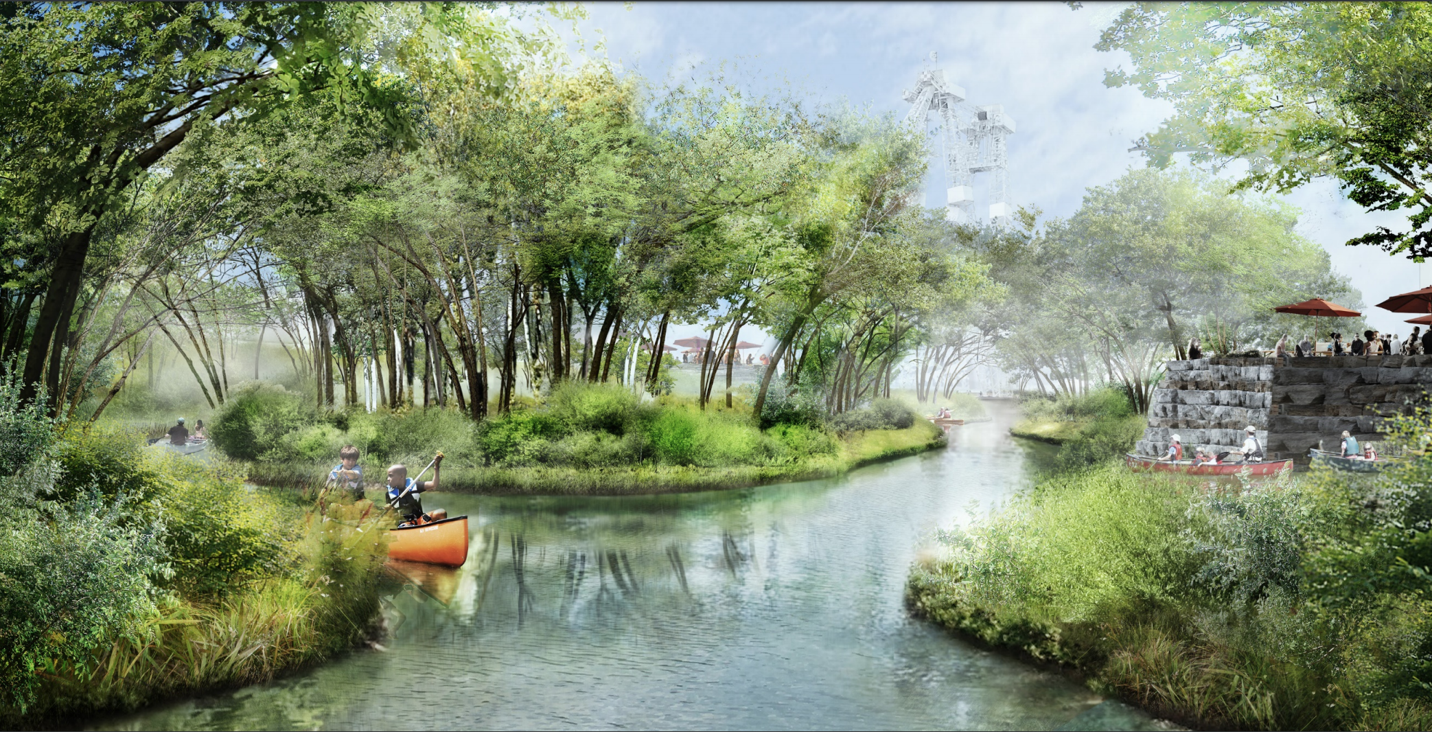
A rendering of human activities around a restored wildlife habitat. Source: https://portlandsto.ca/wp-content/uploads/2018.07.18_PLFPEI_Public-Consultation-Presentation-2.pdf
This stands slightly apart from “nature-led practices,” in which practitioners draw inspiration from natural systems and advocate for their incorporation into contemporary design practice. Ian McHarg articulated this in Design with Nature, in which he argues for an embrace of the inherent dynamism of natural systems and a leveraging of these systems to create more stable landscapes. He refers to dune grass as “the hero of Holland,” as it stabilizes the dunes that naturally protect low-lying lands from storm surges from the North Sea. He encourages designers to understand how natural forms can offer guidance on how to design modern interventions.[4] Another example of a nature-led project might be Kate Orff’s Living Breakwaters, also known as “Oystertecture.” The premise is simple: to bring back the oysters that, back in the day, carpeted the floor of New York Harbor. The oysters had provided ecologically essential services like water filtration and provided a physical barrier against storm surges. Centuries of dredging the bay to allow the passage of cargo ships, and centuries of pollution from those industrial activities, had cleared they bay of its oysters, leaving the city vulnerable. Orff proposes that the oysters be brought back into the bay through the construction of a series of artificial reefs that would support their growth and proliferation and break any storm surges that might threaten the city.[5]

McHarg’s functional dune system, from Design with Nature.
There’s something inherently pleasing about these projects, a satisfying just-so-ness. It’s comforting to think that the solution, the foundation of our resilience, is right in front of us—or rather, right behind us, back there, in the natural past.[6] But what I’m interested in is not necessarily rewilding as a functional exercise, but rather as an aesthetic one. Neither McHarg nor Orff see their projects as singularly aesthetic: McHarg frames his resilient dune as the perfect place for a highway (hardly an aesthetically beautiful piece of infrastructure); Orff’s oysters are functional objects, submerged below the water, not visible to people on the shore (and in any case, the humble oyster is rather unglamorous to behold).[7] In the Don Mouth Naturalization project, the riparian ecology and is not only functional, but an aesthetic object in the landscape, designed to be observed and engaged with; rivers are kayaked in, glades are walked through, marshes are looked out upon. In this context, restoration emerges as an aesthetic exercise, an endeavor to (re)create an image of a past or lost wilderness.
This is odd for a few reasons. Not only does it seem to ignore differences in aesthetic preference for landscape across demographics, but it also suggests that this there’s a direct correlation between functional ecosystems and beautiful landscapes.[8] But as geographer Matthew Gandy suggests, a healthy ecosystem isn’t necessarily an aesthetic pleasure: a rotting carcass covered in maggots is integral to ecology, but not considered beautiful in a cultural sense.[9] In Cambridge this spring, I saw flyers that urged people to not clean up the decaying, and unsightly, leafmatter in their yards, as it’s an important insect habitat. Joan Nassauer’s seminal work “Messy Ecosystems, Orderly Frames,” shows that we often recoil from the chaos of a functional ecosystem, and seek to “frame” it—formally but also conceptually.[10] Quite apart from its unsightliness, wilderness, as we’ll see, can be terrifying, disgusting, and just generally disagreeable. What, then, accounts for our current interest in the aesthetic dimension of a functional nature?
In this column, I’ll write about the aesthetic project of the wild, and one project in particular where these dynamics are at play, at Hunters Point South in New York. I might take some detours to talk about old maps. Readers will please forgive my obsession, and will know where to find me on an average weekend afternoon: perusing the bins at Ward Maps on Mass Ave. Maybe I’ll see you there.
[1] Dennis Cosgrove, “Moving Maps,” in Geography and Vision: Seeing, Imagining and Representing the World (I. B. Tauris, 2008).
[2] For more, see Rob Kitchin, Chris Perkins, and Martin Dodge, “Thinking about Maps,” in Rethinking Maps: New Frontiers in Cartographic Theory (London ; New York: Routledge, 2009) and Jill Desimini and Charles Waldheim, eds., Cartographic Grounds: Projecting the Landscape Imaginary, Illustrated edition (New York: Princeton Architectural Press, 2016).
[3] There are so many questions to be posed of the Don Mouth Naturalization project: who is the restored nature for? What does this project imply about human and non-human use of space? I will not be posing these questions in this column, but encourage people to read Robin Wall Kimmerer’s Braiding Sweetgrass, which illuminates indigenous relationships with land and encourages non-extractive practices. There’s critique to levy of these sorts of projects around the concealing power of the natural image. See Jennifer Foster, “Restoration of the Don Valley Brick Works: Whose Restoration? Whose Space?,” Journal of Urban Design 10, no. 3 (October 1, 2005): 331–51, https://doi.org/10.1080/13574800500297702.
[4] Ian L. McHarg, Design with Nature, 1st Edition (American Museum of Natural History, 1969), 11
[5] “Oyster-Tecture,” SCAPE, accessed May 11, 2020, https://www.scapestudio.com/projects/oyster-tecture/.
[6] There’s also some inherent magnetism between rewilding and resilience: both words make use of the prefix “re-,” Latin for back.
[7] McHarg, 14; “Oyster-Tecture - Episode Text Transcript,” 99% Invisible (blog), accessed May 10, 2020, https://99percentinvisible.org/episode/oyster-tecture/.
[8] Roundtable: Parks and Green Space - Does Everyone Feel Welcome?, 2020, https://www.youtube.com/watch?v=H5QjIpbpIUM&ab_channel=FutureofLondon.
[9] Matthew Gandy, “Marginalia: Aesthetics, Ecology, and Urban Wastelands.” Annals of the Association of American Geographers 103, no. 6 (2013): 1301–16.
[10] Joan Iverson Nassauer, “Messy Ecosystems, Orderly Frames,” Landscape Journal 14, no. 2 (1995).